
Precipitable Water Vapour (PWV) 2D plots
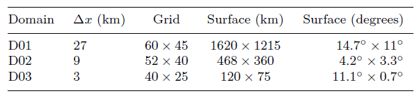
The next animations show the 2D forecasted distribution and evolution for the next 72 hours of the Precipitable Water Vapor (PWV) every 3 hours above the observatory height. In ForO, the WRF model has been configured to run on three nested domains (d01, d02 and d03) centered at Observatorio del Roque de los Muchachos (ORM) and Observatorio del Teide (OT) with horizontal resolutions of 9, 3 and 1km respectively. Details on the domain configurations can be seen in the following table:
In these maps, the PWV has been computed integrating the water vapor mixing ratio from the long-term mean pressure level corresponding to the observatory height, up to 10 hPa. In the Canary Islands the predominant presence of a temperature inversion caused by subsidence, helps to trap most of the water vapor below it maintaining relatively dry and transparent skies above. Atmospheric water vapor decreases steadily in the vertical and most of the time it is confined in the first kilometers above the surface. This is clearly seen in the following mean and median vertical profiles of the water vapor mixing ratio obtained with data from 100 atmospheric balloons launched from Güímar sounding station (WMO station 60018):
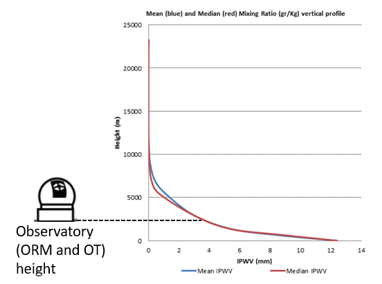
Above the observatories (approximately 2400 m height) low levels of vapor mixing ratios are usually found. Some days, however, the subsidence inversion weakens or completely breaks down, allowing some water vapour to reach higher levels and thus increasing the PWV above summit. This is why ForO system provides this kind of plots, helping the user to trace future moist airmasses passing above the observatory thus compromising infrared observations. They also give a synoptic view of the PWV structure at different spatial scales.
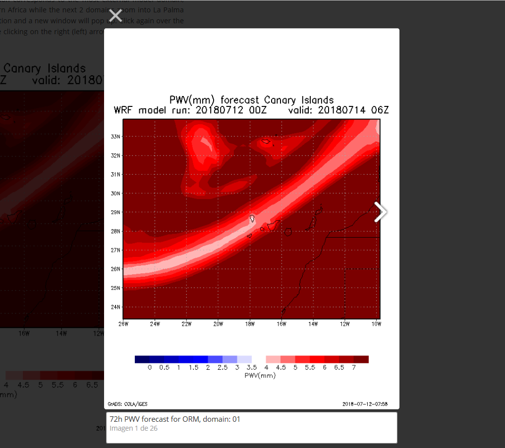
Grid Analysis and Display System (GrADS) has been used to automatically generate PWV 2D plots. The first animation corresponds to the most external model domain, covering the Canary islands, while the next 2 domains zoom into La Palma island. The animation it’s a movie of the forecasted evolution of the PWV above the observatory height in 3 hours time steps. To access the individual maps just click over the animation and a new window will pop up, in which the animation is shown again:
Click again over the animation and now you can move forward (backward) in time clicking on the right (left) arrow that appears over the map left and right side, as shown in the next figure:
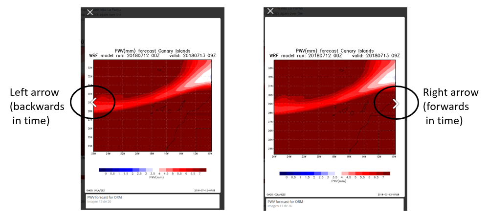
This allows the user to check PWV forecast conditions for certain hours during a night. The header of each map shows the WRF model run start date and time and the valid date and time for the current map being shown.
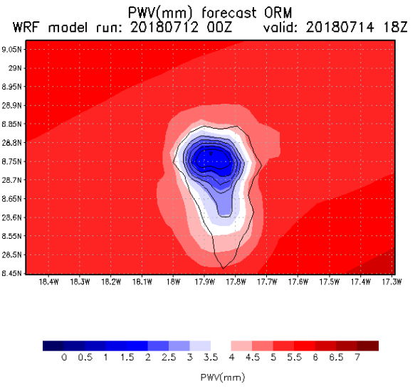
Note on the Color bar used in these plots
The color bar in this 2D plots has been configured to enhance the detail in the low (i.e: PWV < 4 mm) values of PWV. The color bar has been centered on the median for the ORM (PWV=3.9mm) obtained by García-Lorenzo et al (2010). "Cold" (blue) colors reflect a dry atmosphere above the observatory likely suitable for infrared observations, while “Warm” (red) colors reflect a moist atmosphere not so transparent at infrared wavelengths. Using this customized color bar, we can visualize a richer spatial structure of the PWV above the observatory, as shown in the following example for the ORM:
Credit must be given for Ted Letcher, who has developed the colormaps script we chose to use in ForO.
References:
Pérez-Jordán G., Castro-Almazán J. A., Muñoz-Tuñón C., Codina B., Vernin J., 2015, Monthly Notices of the Royal Astronomical Society, 452, 1992
Castro-Almazán J. A., Muñoz-Tuñón C., García-Lorenzo B., Pérez-Jordán G., Varela A. M., Romero I., 2016, in Observatory Operations: Strategies, Processes, and Systems VI. p.99100P, doi:10.1117/12.2232646
G Pérez-Jordán, J A Castro-Almazán, C Muñoz-Tuñón; Precipitable water vapour forecasting: a tool for optimizing IR observations at Roque de los Muchachos Observatory, Monthly Notices of the Royal Astronomical Society, Volume 477, Issue 4, 11 July 2018, Pages 5477-5485, https://doi.org/10.1093/mnras/sty943
Grid Analysis and Display System (GrADS): http://cola.gmu.edu/grads/
Colormaps (Ted Letcher): http://gradsaddict.blogspot.com/2014/05/script-colormapsgs-very-easily-create.html
